 As announced earlier India's own geographic information system (GIS) dubbed 'Bhuvan' is now available for download, currently under BETA release country's indigenous Google Earth is capable of Indian specific features not available in any other competing product, Bhuvan features multiple layers of information showing topography, altitude, depth weather and other features helpful in managing public services, internal security, town planning, and infrastructure development activities.
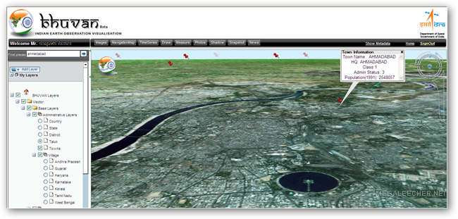
The web-based portal requires an initial plugin download in order to provide promising high-resolution 3-D satellite imagery with smooth video acceleration, Bhuvan offers images of the globe similar to Google Earth but provides best resolutions over the Indian sub-continent with ISRO having plans to expand high-resolution images globally.
Bhuvan Features :
* Access, explore and visualise 2D and 3D image data along with rich thematic information on Soil, wasteland, water resources etc.
* Visualise multi-resolution, multi-sensor, multi-temporal image data
* Superpose administrative boundaries of choice on images as required
* Visualisation of AWS ( Automatic Weather Stations) data/information in a graphic view and use tabular weather data of user choice
* Fly to locations ( Flies from the current location directly to the selected location)
* Heads-Up Display ( HUD) naviation controls ( Tilt slider, north indicator, opacity, compass ring, zoom slider)
* Navigation using the 3D view Pop-up menu (Fly-in, Fly out, jump in, jump around, view point)
* 3D Fly through (3D view to fly to locations, objects in the terrain, and navigate freely using the mouse or keyboard)
* Drawing 2D objects (Text labels, polylines, polygons, rectangles, 2D arrows, circles, ellipse)
* Drawing 3D Objects (placing of expressive 3D models, 3D polygons, boxes)
* Snapshot creation (copies the 3D view to a floating window and allows to save to a external file)
* Measurement tools (Horizontal distance, aerial distance, vertical distance, measure area)
* Shadow Analysis (it sets the sun position based on the given time creating shadows and effects the lighting on the terrain)
* There would be many more value added functions and facilities which will be added into the package from time to time.
* Particular interest of ISRO/DOS would be to provide such functionalities to common man so that he/she adopts participatory approach with scientists to solve simple problems easily and interactively.Advanced functionality to be provided in future versions
Urban Design Tools (to build roads, junctions and traffic lights in an urban setting)
o Contour map ( Displays a colorized terrain map and contour lines)
o Terrain profile ( Displays the terrain elevation profile along a path)
o Draw tools (Creates simples markers, free hand lines, urban designs)
o Navigation map (to jump to and view locations in the 3D India)
You need to register and download the plugin in order to view the virtual earth in 3D space.
Comments
Easy way to get connected to Bhuvan
Yeah in case if you are unable to connect to http://bhuvan.nrsc.gov.in you can even go to the site
http://bhuvan2.nrsc.gov.in/bhuvan/webclient/presentationlayer/webclient/index.aspx
Amruthapani
download bhuvan
i cannot download pls help
good
good
I'm not very happy...
I'm not giving it a review point. I'm just not happy to have this kind of service since I'm afraid if anti-national elements would use this information for terrorism and the like.
And why the heck isn't this on news channels yet ? I think its a pretty big accomplishment.
wowwwwwwww!!!!!
Thanx man!
Bhuvan
Although I am Indian, i thought they would do a better job,They don't have enough clarity. If its like this i dont think they can compete against google earth, they need clarity about the town and villages...This is just an opinion
Jai Hind..Let India Rule...
http://www.megaleecher.net/Bhuvan
tanks for applications hudy from... indonesia
Bhuvan
I don't think that it can beat the google earth in clearity, as u get more zoom it becomes more hazzy.
ERROR MESSAGE : DDERR. OUT OF VIDEO MEMORY WHEN LOADING BHUVAN
I am unable to view Bhuvan. After installing, when I load Bhuvan, it gives an error message " DDERR OUT OF VIDEO MEMORY". However, I have no problem in viewing Google Earth. I have 3D labs Wild Cat4 7100 graphic card in my PC. If anyone can help me out as how to solve this problem? Pl helpl.
Goooooooood
Thanks
download problem
cannot download pls help
Me dr Arun
its exiting to see bhuvan
Add new comment